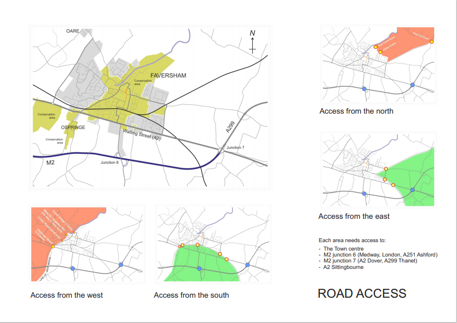
Road access
Most of the development will take place around the periphery. The surrounding area divides naturally into four quadrants: north, south, east and west. The west quadrant is the most problematic.
(a) It is cut off from the Town centre and from access to M2 junctions 6 and 7 by three conservation areas (Syndale, Ospringe and Faversham) that form an arc around the western side leaving a narrow gap at Ospringe (shaded in brown in the central map).
(b) There are only four crossings over the Creek and Westbrook, which act as ‘gateways’ through areas of high heritage value, including the Creek bridge (single lane) and the West Street/Napleton Road one-way complex (brick paviours and speed humps through narrow residential streets in a conservation area). The main gateway is through Ospringe along Watling Street, which is less than 2 lanes wide. Two lorries cannot pass through the bottleneck in opposite directions at the same time.
Together, these bottlenecks limit the extent to which the Town can be developed round its western flank – there is no spare capacity for movement to and from the Town centre or the M2. Further traffic growth would compromise a large section of Watling Street. Conclusion: development to the west is not a sustainable solution without a new link to the M2.
Similarly, the north quadrant has limited development potential because the only viable ‘gateway’ to the Town centre and to the M2 is via the Whitstable Road.
By contrast, the south and the east quadrants have reasonably free access to the Town centre and both have direct and unimpeded access to the M2, via junction 6 or junction 7.
Vehicular movement
There are two maps showing vehicular traffic flows. The one on the left represents total traffic while the one on the right represents HGVs. They are plotted on different scales and since the data for the two maps comes from two different sources, they are not entirely consistent. They are also out of date, but in any case we no longer have steady long-term growth: the trend has been broken by COVID, and both the Lower Thames Crossing and BREXIT will deliver additional traffic demand along the M2 for which we don’t yet have reliable estimates.

Active travel
Watling Street is currently a major distributor for industrial traffic as well as private cars, and causes ‘severance’ for communities livening on opposite sides. Since the Town is now spilling southwards it will become the central spine, and the degree of severance will get worse. The street has only two designated crossing places within the Town boundary.
It’s not the only barrier to pedestrian movement. There are pedestrian bridges over the railway lines but they’re not accessible to prams, pushchairs, bicycles or the disabled. They will require an upgrade if the Town is to develop to the south-east.

The future network
We could advocate ‘School Streets’ (no cars during the start and finish of the school day) and make 20’s Plenty permanent, as groundwork in preparing for change. Other options include ‘walking buses’ and park-and-ride.
There are four main options for relieving Watling Street from unsustainable traffic growth and re-purposing it as the Town’s main thoroughfare for all users. Option 3, a new link to the M2 at Syndale is highly desirable but unlikely to happen for a decade or two – there is no appetite at central government level for improving junctions at our end of the M2 even with the threat of extra demand arising from the Lower Thames Crossing. Option 1 may also be ruled out because another junction with A251 is tricky if not impossible.
That leaves us with Options 2 and 4. To protect Watling Street in its new role, (and save Ospringe and its built heritage from further erosion), where possible the local authorities could encourage a gradual shift of industrial development from Oare to the south-eastern corner of the Town. Regardless of any infrastructure investment, the Town Council may wish to campaign for a culture change, using private cars less and switching to ‘active travel’.

Design principles
Street layout in new residential estates
New residential estates should ‘join up’ with the existing infrastructure rather than forming isolated enclaves, and they should provide continuity in bus routes, cycleways and pedestrian routes that encourage ‘active travel’. Will developers collaborate?
Footways and junction design
When development spills across Watling Street there will be a much greater demand for pedestrian movement both along and across the road, which is currently not provided for. There is a significant stretch with no footway on the south side at all. Many junctions have wide kerb radii to ease the movement of vehicles round corners. This penalises walkers, as shown in the diagram.